The Burnt Fork Watershed encompasses an area of approximately 5 square miles in DeKalb County , Georgia that is, for the most part, bordered by LaVista Road and Lawrenceville Highway from Tucker to near Emory University in Decatur . Water that drains into Burnt Fork Creek comes from the neighborhoods of Northeast DeKalb County, the business districts of Northlake, and the industrial area along Montreal Drive and Montreal Circle. Other large contributors of stormwater include the DeKalb County School System (maintenance facilty on Montreal Rd, Shamrock Middle School, Laurel Ridge Elementary, and , administrative offices on Lawrenceville Hwy).
Flooding along Burnt Fork Creek has been an increasing problem in the last 30 years. Many assume that this is a stable watershed, with little development. However, the truth is that construction continues along with redevelopment, especially in residential areas, where an increase in density has greatly increased the amount of stormwater entering the creek.
DeKalb County's recent Hazard Mitigation Plan barely even mentions Burnt For Creek.
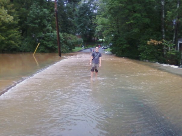
Burnt Fork Creek flooding over Riderwood Dr, September 2009
Photo by Susan Summers
Atlanta Regional Commission information on Peachtree Creek watershed
Impervious surfaces are those surfaces that do not allow water to penetrate, such as those created by the construction of parking lots, driveways, roofs, patios, sidewalks and roads.
Burnt Fork Watershed impervious surfaces preliminary calculations:
The Burnt Fork Sub-Watershed covers an area that is approximately 133,080,000 square feet or 4.77 square miles.
A mile is 5280 feet in length. A square mile is 27,878,400 square feet. 133,080,000 / 27,878,400 = 4.77 square miles.
The impervious surfaces outside I-285 total approximately 11,072,500 square feet or 0.4 square miles. The impervious surfaces inside I-285 in the predominantly commercial area East of Montreal Road total approximately 16,395,000 square feet or 0.59 square miles. The impervious surfaces inside I-285 and West of Montreal Road total approximately 28,058,000 square feet or 1.01 square miles. Lastly, there is approximately an additional 7,500,000 square feet or 0.27 square miles for the homes in the entire watershed (3000 residences times 2500 square feet = 7,5000,000).
11,072,500 + 16,395,000 + 28,058,000 + 7,500,000 = 63,025,500 square feet of impervious surfaces.
63,025,500 / 133,080,000 = .4736 = 47.36 % impervious surfaces
With the Burnt Fork Watershed impervious surface percentage calculated at approximately 47.36 % Burnt Fork Creek is considered "non-supporting". The "Rapid Watershed Planning Handbook, A Comprehensive Guide for Managing Urbanizing Watersheds - October 1998" describes non-supporting streams as those whose quality has crossed a threshold. It states that streams in this category essentially become a conduit for conveying storm water flows, and can no longer support a diverse stream community.