The Burnt Fork Watershed encompasses an area of approximately 5 square miles in DeKalb County, Georgia that is, for the most part, bordered by LaVista Road and Lawrenceville Highway from Tucker to Mason Mill Park near Emory University in Decatur. Water from the Burnt Fork Watershed drains into Burnt Fork Creek which flows through the business districts and neighborhoods of Northeast DeKalb County. The Burnt Fork Watershed is 1 of the 27 sub-watersheds that make up the Peachtree/Nancy Creek watersheds, in the Chattahoochee River Watershed.

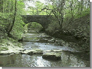
the bridge across Burnt Fork Creek near the Old Decatur Water Works in Mason Mill Park
Burnt Fork Creek was once the water supply for the city of Decatur. This was accomplished by damming the creek to form a reservoir. The Old Decatur Waters Works located in Mason Mill Park served as a treatment and pumping facility. The Old Decatur Water Works first saw use just after the turn of the twentieth-century.
The main administrative building was built in around 1906. Native Americans also inhabited the area along the creek. Artifacts collected in the area indicate that there has been habitation along the creek as long as 2000 to 3000 years ago, University of Georgia Archeology Department official site number, 9DA352.
In 1942 the water works provided area residents and businesses with up to 1.8 million gallons of water per day. Prior to the construction of the waterworks, a mill was constructed on the site in around 1860. It is believed that Union and Confederate soldiers fought in the area as evidenced by an unexploded artillery round found in the 1970's. During World War II the water works supplied water to the Naval Air Station in Chamblee and an Army Hospital . The water works was off limits to residents during the war to protect the water supply. After the war, DeKalb County used the area as a storage facility. In 1951 DeKalb County Commissioners tried to issue bonds to restore the park. The commissioners were unsuccessful in their efforts to restore the park and in the 1960's the dam was destroyed and the reservoir was allowed to drain. A new park was conceived in 1988, designed around the water works and its 85 acres of land. The master plan for the new park was drawn up by W. L. Jordan & Co, Inc, Engineers-Surveyors-Planners and featured nature trails, boardwalks with pedestrian bridges and a nature center. The plan was adopted by the DeKalb County Board of Commissioner on the 21st of December, 1988 and signed by Manuel Maloof, Chief Executive Officer, at the time. Funding was never realized for the master plan and the area has since fallen into dis-use except by area residents who enjoy its undisturbed natural beauty. DeKalb County now gets its water from the Chattahoochee River.

Today, Burnt Fork remains one of Atlanta's most beautiful and well-preserved creeks and aquatic greenways. Despite the pressures of deforestation and urbanization Burnt Fork Creek still manages to support Bass, Blue Gill, Perch, Brim and amphibians. It also provides a habitat for over 50 species of birds, Beavers, Red Foxes and perhaps most interestingly, River Otters. It is likely that the presence of such diverse wildlife in and along the Burnt Fork Creek aquatic greenway is a manifestation of the dwindling natural habitats in urban Atlanta. With the uncontrolled urban sprawl and relentless deforestation in the Atlanta area it is essential that natural habitats such as Mason Mill Park and the Burnt Fork Creek aquatic greenway be protected for these creatures. It is likely that the presence of such diverse wildlife in and along the Burnt Fork Creek aquatic greenway is a manifestation of the dwindling natural habitats in urban Atlanta. Unfortunately, due to the aforementioned pressures of urbanization, the entire 6 miles of Burnt Fork Creek are on the Georgia Environmental Protection Division's 303 (d) list as not supporting its designated uses. The main problem is elevated levels of fecal coliform bacteria due to urban runoff.
In addition to the stresses put upon the watershed by rainwater runoff. The Georgia Rail Passenger Authority (GRPA) has proposed constructing at least two (2) additional tracks along the existing rail line within the one hundred-foot (100') right-of-way of the CSX rail corridor. These additional tracks, if constructed, will provide commuter rail service from Athens to Atlanta for approximately 7900 people daily. Burnt Fork Creek follows the CSX rail corridor for six (6) miles from Tucker to Mason Mill Park where it enters South Peachtree Creek. Any construction within the CSX right-of-way will destroy Burnt Fork Creek and its watershed, as well as, ruin the natural beauty of Mason Mill.
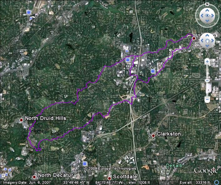
Map of Metro Atlanta showing Burnt Fork Creek Watershed

Google Map completed by Jon Becker
The watershed goes form the headwaters of Burnt Fork Creek in Tucker, between La Vista Rd and Lawrenceville Hwy, and runs to the confluence with the South Fork of Peachtree Creek in Mason Mill ParkMap loading...
To join our email list, please send an email to burntforkcreek+subscribe@groups.io
Become a fan on Facebook
Visit https://www.facebook.com/burntforkcreek.ga

